

List of Typical IPS Equipment
The system has 4 major components:
1. ORE Broadband Acoustic Tracking System (BATS).
2. A GPS receiver that supports the GGA data format, a National Marine Electronics Association (NMEA) data string version 1.5 or higher. For example:
$GPGGA,154325,2939.551,N,09533.814,W,9,5,002,0018,M,-06,M
and optionally the following NMEA data strings:
VTG- Vessel's Course and Speed over ground ($GPVTG,016.7,T,,,08.5,N,,)
ZDA- Date time
HDT- True heading (available from GPS positioning and heading systems ("GPS Gyro") or as a pass thru function)
The first data string (GGA) contains the ship's position in latitude and longitude. Latitude and longitude minutes carried out from 3 to 6 places right of the decimal point are acceptable. A check sum at the end of the $GPGGA data string is acceptable but not necessary. The optional data strings (VTG) contains the ship's course and speed over ground, (ZDA) data time and the (HDT) vessel's true heading.
3. GPS positioning and heading (GPS-GYRO) system, gyrocompass or flux-gate compass to provide vessel heading information. The heading data can be sent to the IPS program through a serial port multiplexer, a USB RS-232 converter or Ethernet RS-232 converter.
Note: Please contact ORE Technical Support Contacts for additional assistance in compass selection. The following is a list of acceptable compasses:
A. An EdgeTech ORE Motion Reference Unit (MRU) Model No. ($POREM), NMEA format $PRDID or Maretron SSC200 solid state compass ($PMAROUT).
B. Any device that outputs an NMEA data string in HDM, HDT, HDG, VHW or TSS HHRP format containing the ship's heading. Examples are compasses produced by EdgeTech, Subsea Technologies, KVH Industries, Inc., Furuno, and Raytheon among others. See the Technical Support Contacts section of this manual for information on contacting these companies. Other formats may be supported, please contact ORE for assistance. Please see the section GPS Receiver in this manual for more information.
C. Heading sent directly to the PC via Ethernet using UDP (F-180 MCOM format). Please see the section on System Interfacing in this manual for more information.
4. A PC with XP or Vista 32 bit, Windows 7 32 or 64 bit and Windows 10 32 or 64 bit, 600 x 800 graphics or better and one available USB port with a USB-RS232 converter and one Ethernet port.
10
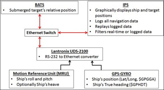
Suggested BATS-IPS Setup