

IPS Installation Steps
IPS Installation Steps
1. Run the IPS setup.exe.
2. Insert the IPS Security Key:
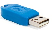
Figure 1. IPS USB Security Key
Setup IPS Communication Port
Serial Ports
1. Run the IPS from desk top Icon  .
.
2. Depending on the system setup select serial or ethernet port as required for GPS or VRU data depending on the GPS. From the Main menu select Setup Menu->Communications Command.
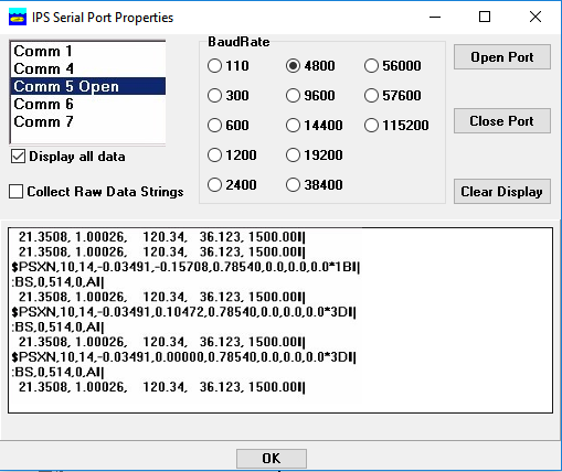
1. Select a Serial port from the upper left list box (i.e. Comm 1).
2. Select a Baud Rate (typically NMEA devices default to 4800 baud).
3. Click on the [Open Port] button. Data from that device if available will be displayed in the
“in coming data area” below.
4. Continue this process until the necessary devices are on-line and being received by the IPS. This typically includes: GPS (Ship lat/long), ship’s heading sensor (Fluxgate compass or gyro) and remote VRU.
Ethernet UDP Ports
1. From main IPS menu select Setup->Ethernet Settings.
2. Select an unused UDP port.
3. Typically "Header-Special Processing"can be set to None.
4. Set Local Port number to the UDP port number that the RS-232 converter transmits the data to.
5. Click on the "Receive Data"check box.
6. If the IPS is required to transmit data to another device/PC set the Remote Port and IP address of the remote device. Note the data format and target number being used are set in the Setup->Serial Out Command menu option.
Setup/configuration of IPS Input Devices
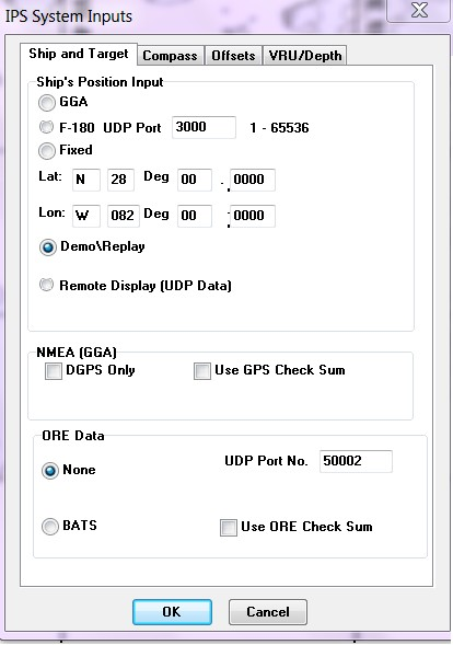
1. If GPS NMEA positions are available select GGA or otherwise:
2. Enter a fixed lat/long position or
3. for CodaOctopus F180 or F190 systems select “F180 UDP”.
4. Check DGPS only and Use GPS Check Sum boxes if required for GGA input.
5. Select EdgeTech USBL Tracking System: BATS.
6. Select the System Input “Compass” tab.
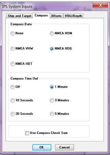
1. Select the compass data format style. For NMEA 0183 serial data being received select the corresponding format. Typically the format HDT is provided by North seeking Gyros and HDM or HDG formats are provided by magnetic sensing based heading sensors (Fluxgate compasses etc.) Note if an Attitude Heading Reference System (AHRS) is being used such as TSS MAHRS, IXSA Octans or CDL MiniRLG/MiniPOS set the compass data field to none.
2. Note if the heading sensor provides an NMEA style check sum the user can select the check box “use Compass Check Sum”. The check sum field will have the following format ‘*CS’ where the ‘*’ will precede the actual check sum characters that range from 0..9, and A..F (hex encoded ASCII).
3. The remaining two tabs “Offset” and “VRU/Depth” allow for the configuration of an Attitude Heading Reference System (AHRS) as a TSS MAHRS, IXSA Octans or CDL MiniRLG/MiniPOS and allow the user to select the data format for NMEA depth data strings.
4. If valid data from the external devices (ORE USBL, GPS, compass etc.) is being received by the IPS, then the IPS should display the data in text format in the Position Boxes on the right side of the screen and graphically in the center of the screen.